Optimal 3D reconstruction of plants canopy from terrestrial laser scanner data by fusion of the 3D point information and the intensity value - INRIA - Institut National de Recherche en Informatique et en Automatique Accéder directement au contenu
Communication Dans Un Congrès Année : 2013

Optimal 3D reconstruction of plants canopy from terrestrial laser scanner data by fusion of the 3D point information and the intensity value

Résumé

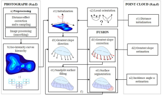
We develop an algorithm to digitize in situ canopy and to tag automatically each of its leaves. This algorithm fuses the distance information and the intensity values of a terrestrial LiDAR scanner.
Fichier principal
Vignette du fichier
BalduzziBoudonGodin2013.pdf (273.53 Ko) Télécharger le fichier
Vignette du fichier
balduzzi13.jpg (97.03 Ko) Télécharger le fichier
Origine : Fichiers produits par l'(les) auteur(s)
Format : Figure, Image

Dates et versions

hal-00850793 , version 1 (08-08-2013)

Identifiants

  • HAL Id : hal-00850793 , version 1

Citer

Mathilde Balduzzi, Frédéric Boudon, Christophe Godin. Optimal 3D reconstruction of plants canopy from terrestrial laser scanner data by fusion of the 3D point information and the intensity value. 7th International Conference on Functional-Structural Plant Models, Jun 2013, Saariselkä, Finland. pp.58-60. ⟨hal-00850793⟩
308 Consultations
1123 Téléchargements

Partager

Gmail Facebook X LinkedIn More