

Watertight Scenes from Urban LiDAR and Planar Surfaces
Résumé
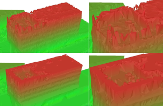
The demand for large geometric models is increasing, especially of urban environments. This has resulted in production of massive point cloud data from images or LiDAR. Visualization and further processing generally require a detailed, yet concise representation of the scene's surfaces. Related work generally either approximates the data with the risk of over-smoothing, or interpolates the data with excessive detail. Many surfaces in urban scenes can be modeled more concisely by planar approximations. We present a method that combines these polygons into a watertight model. The polygon-based shape is closed with free-form meshes based on visibility information. To achieve this, we divide 3-space into inside and outside volumes by combining a constrained Delaunay tetrahedralization with a graph-cut. We compare our method with related work on several large urban LiDAR data sets. We construct similar shapes with a third fewer triangles to model the scenes. Additionally, our results are more visually pleasing and closer to a human modeler's description of urban scenes using simple boxes.
Domaines
Informatique
Fichier principal
 SGP1064.pdf (12.32 Mo)
Télécharger le fichier
SGP1064.pdf (12.32 Mo)
Télécharger le fichier
 vanKreveld2013thumb.jpg (290.82 Ko)
Télécharger le fichier
vanKreveld2013thumb.jpg (290.82 Ko)
Télécharger le fichier
Origine : Fichiers produits par l'(les) auteur(s)
Format : Figure, Image
Loading...